2025. 2. 27. 05:16ㆍWonderful World
View of Mokopuna (at left) and Matiu (Somes Island) in Wellington Harbour
from Orissa Crescent, Broadmeadows, Wellington City

Johnsonville, Broadmeadows, Khandallah below,
with Wellington Harbour, Petone, Seaview, Matiu Somes Island and Wainuiomata beyond.
Aerial view, Johnsonville, Wellington City District, Wellington Region, New Zealand (NZ)

Wellington City Centre and harbour from Mount Victoria

Lambton Harbour and the Wellington Waterfront
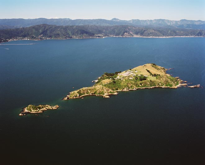
The three Harbour Islands
Mātiu/Somes, Makāro/Ward, and Mokopuna,
Wellington Harbour’s three islands

Matiu/Somes Island looking south over Wellington Harbour

Matiu Somes Island in Wellington Harbour

Victoria University's Kelburn campus, one of four in Wellington

Wellington hospital

Firth Hall, left, and the former College Hall, right
Wellington_college

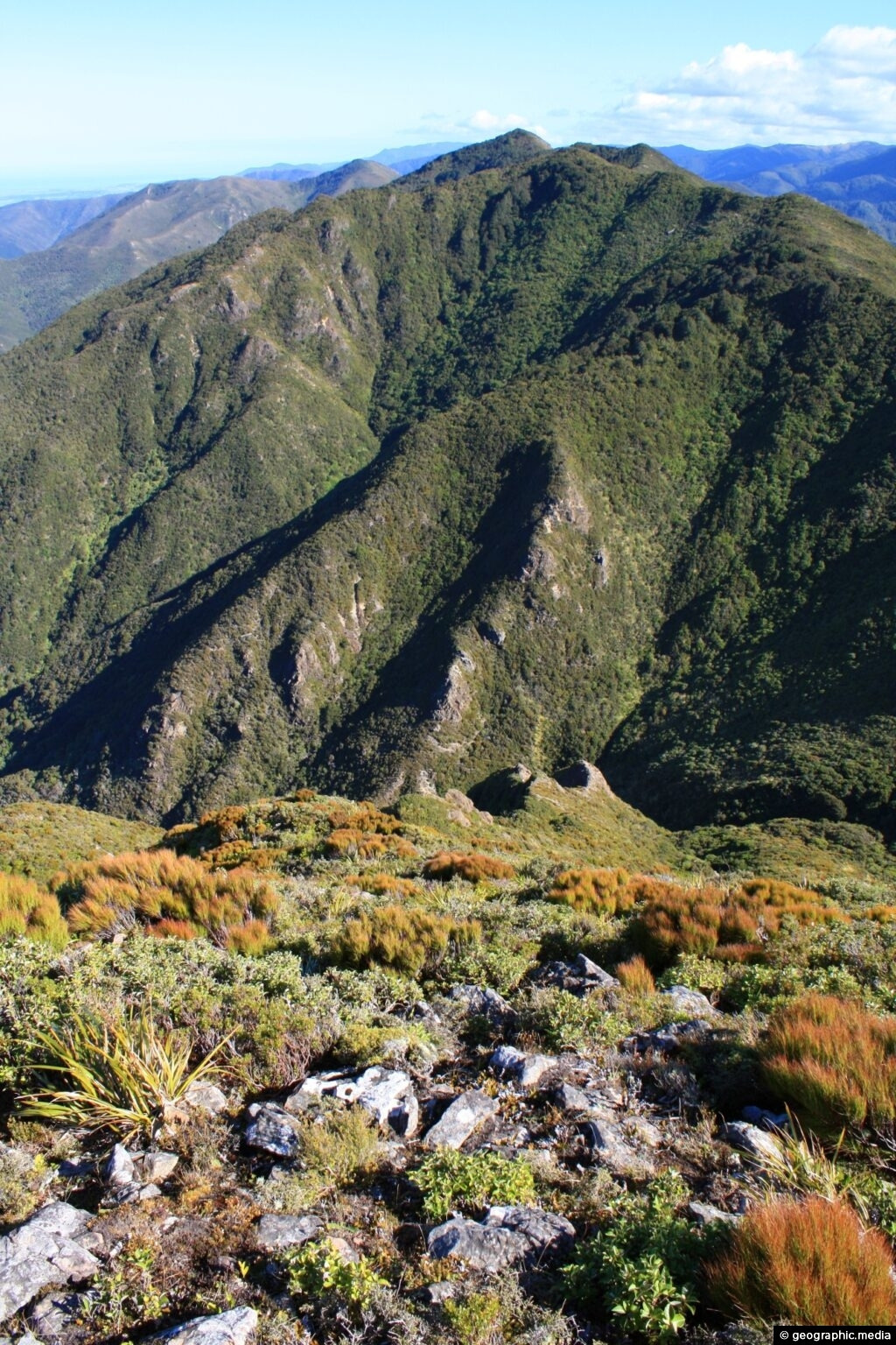
Tararua Range & Rimutaka Hil

The Tararua Range, often referred to as the Tararua Ranges or Tararua, is one of several mountain ranges in the North Island of New Zealand.

Pasture_against_snow
Tararuas from Wairarapa
The Tararua Range runs northeast–southwest for 80 km (50 mi) from near Palmerston North to the upper reaches of the Hutt Valley, where the northern tip of the Remutaka Range begins. It is separated in the north from the southern end of the Ruahine Range by the Manawatū Gorge. Most of the Range is wilderness, protected as the Tararua Forest Park.

The highest peak in the Tararua Range is Pukeamoamo / Mitre (not to be confused with Mitre Peak) at 1,570 m (5,150 ft). Other prominent peaks include Mount Bannister at 1,537 m (5,043 ft) and Mount Hector at 1,529 m (5,016 ft), which is named after the scientist Sir James Hector. Its Māori name is Pukemoumou, or 'hill of desolation'.

Tararua Ranges behind the Hutt River in Autumn

Remutaka Road, Remutaka Range
The Remutaka Range (spelled Rimutaka Range before 2017) is the southernmost range of a mountain chain in the lower North Island of New Zealand. The chain continues north into the Tararua, then Ruahine Ranges, running parallel with the east coast between Wellington and East Cape.
The 555-metre summit of the road over the range at its northern saddle is named Remutaka Pass. The pass was formally named on 17 December 2015.

Mount Matthews, 940 metres, seen from Kelburn, Wellington
Mount Matthews the highest point in the Rimutaka range, from Wellington

State Highway 2 (Rimutaka Hill Road)
seen from near the top of the pass 555 metres (1,821 ft)

Tararua Range, North Island New Zealand

The webcam on top of the Rimutaka Hill road, Remutaka Range


Aerial Shot of the Rimutaka HIll

Remutaka hill road; tearooms at the summit.
Tearooms at the top of the Remutaka hill road in 1985.
The then 70-year-old tearooms were closed in 2008 and were hit by an arsonist in 2009;
they were then demolished, along with the toilet block.
A memorial to the 60,000 New Zealand troops who made the crossing over the hill
during the First World War was unveiled at the summit in 2015.

Rimutaka Hill march to war
250 March over Rimutakas
The trek from Featherston, in the Wairarapa, over the Rimutaka Hill to Upper Hutt,
was a rite of passage for about 60,000 soldiers bound for The Great War after completing their training.
The Remutaka Hill Road summit was officially renamed 'Remutaka Pass' on December 17, 2015;
'Rimutaka' was a mistaken spelling, and 'pass' was more appropriate than 'summit'.
Remutaka crossing memorial
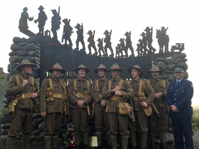
On 27 September 2015, as part of a re-enactment of the Remutaka crossing, a memorial was unveiled. It commemorates 60,000 New Zealand troops who made the crossing between the military camp in Featherston and Hutt Valley between 1915 and 1919.
The memorial, designed by Wairarapa artist Niko Thomsen, features a large stone base constructed by Mike Dunn and steel figures made by Thomsen. The steel figures are approximately 50 cm tall and depict soldiers walking from a vehicle towards a woman with a pot of tea. The memorial represents the experience that soldiers had on the march.

World War I soldiers resting at the top of the Rimutaka hill road.
On completing training at Featherston they marched over the hill to Wellington
to board ship for France's trenches.
View looking south along the Rimutaka Hill road towards Wellington, with soldiers on the verge.

Seventh Reinforcement marching over the Rimutaka Hill


Remutaka (Rimutaka) Hill Road (State Highway 2, SH2) climbing over the Remutaka (Rimutaka) Ranges (to 555m) from Upper Hutt to the Wairarapa. Aerial view on a moody evening, Remutaka, Upper Hutt City District, Wellington Region, New Zealand (NZ)

Remutaka hill view point, Wellington
https://www.youtube.com/watch?v=ZiBlITSL1Yo

Remutaka Hill Road from the Summit, Looking East to the Wairarapa.
"'Sunset gilding' Rimutaka summit".
Taken from the hill road, looking east to the Wairarapa.
The Rimutaka Hill Road summit was officially renamed 'Remutaka Pass' on December 17, 2015;
'Rimutaka' was a mistaken spelling, and 'pass' was more appropriate than 'summit'.

Rimutaka Hill Road on the Wairarapa side.

Mt Climie Remutaka Range
Sub alpine view of the Remutaka Range looking south with Mt Climie visible.
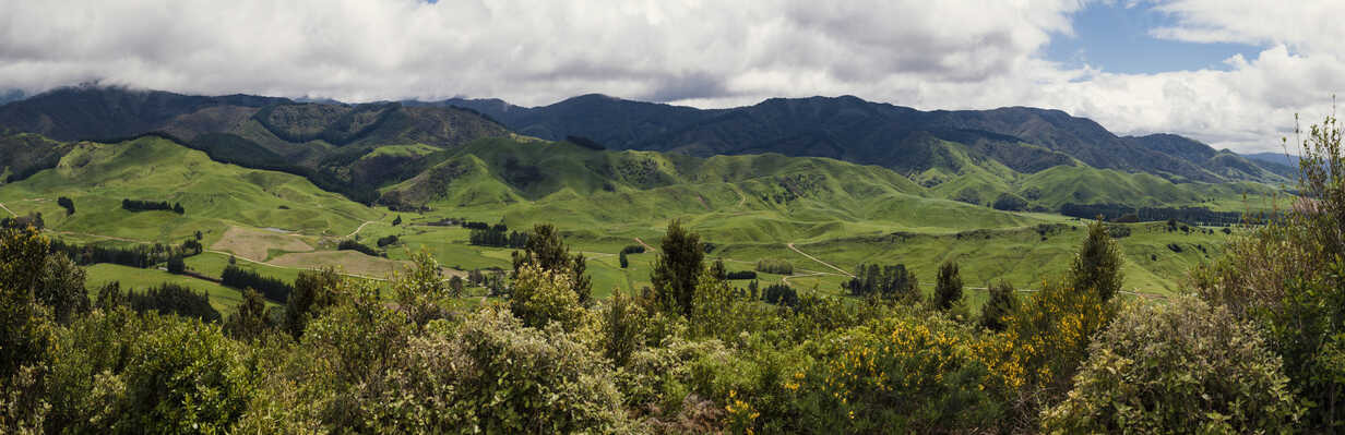
Wellington, New Zealand


Wellington & Tararua Ranges

Pukaha Mount Bruce National Wildlife Centre, New Zealand

Pukaha-Mt-Bruce_entrance

Bruces Hill(719m)
This is the summit of Mt Bruce, with the northern Tararua Range in the background.
The area contains one of the last remnants of the Forty Mile Bush,
and includes Pūkaha Mt Bruce National Wildlife Centre.
Pūkaha / Mount Bruce National Wildlife Centre

Pūkaha National Wildlife Centre is a captive breeding facility and visitor centre located in a protected forest area on State Highway 2 in New Zealand's Tararua district. It was formerly called Mount Bruce National Wildlife Centre, then Pūkaha / Mount Bruce National Wildlife Centre.

Location
Pūkaha National Wildlife Centre is located on State Highway 2, 30 km north of Masterton and 10 km south of Eketāhuna. It is within the Pukaha / Mount Bruce National Wildlife Centre Reserve.
The Pukaha Mount Bruce National Wildlife Centre provides the chance to see endangered native birds, eels and tuatara as part of a native forest recovery programme
The Wildlife Centre is about half-way between Masterton and Pahiatua, and is well sign-posted along state higway 2.

Manukura – the white kiwi

Kākāriki (red-crowned parakeet) eating berries
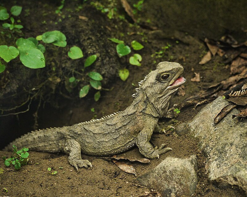
Tuatara
are endemic to New Zealand. They grow very slowly, live to over 100 years old and are the only survivors of an ancient group of reptiles which roamed the earth, along with the dinosaurs, over 200 million years ago. Tuatara are classified as an endangered species and are now found in the wild mainly on over 30 predator-free off-shore NZ islands.
The tuatara (Sphenodon punctatus) is a species of reptile endemic to New Zealand. Despite its close resemblance to lizards, it is part of a distinct lineage, the order Rhynchocephalia. The name tuatara is derived from the Māori language and means "peaks on the back".

'Wonderful World' 카테고리의 다른 글
| Cloughoughter Castle in County Cavan, Ireland (0) | 2025.02.27 |
|---|---|
| Wellington, New Zealand (0) | 2025.02.27 |
| Vaduz Castle, Liechtenstein (0) | 2025.02.27 |
| I'm a solo female traveller - these are my safety ratings for places I was told to avoid (0) | 2025.02.27 |
| 野柳地質公園 Yehliu Geopark 台湾新北市|北海岸景點 (0) | 2025.02.27 |