2025. 2. 27. 05:31ㆍWonderful World


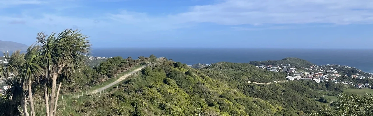
Panorama of Wellington


Panorama of Wellington and surrounds


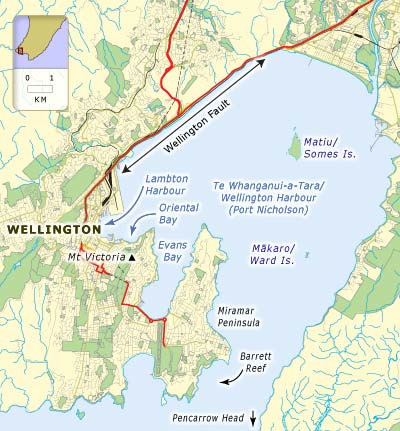
Satellite view of the Wellington area

Lambton Harbour and the Wellington Waterfront

Wellington Harbour (Port Nicholson) and City

Matiu Somes Island is owned by local iwi (Taranaki Whānui) following a Treaty settlement.
It is governed by a Kaitiaki Board and managed by DOC.
Te Whanganui-a-Tara/Wellington Harbour
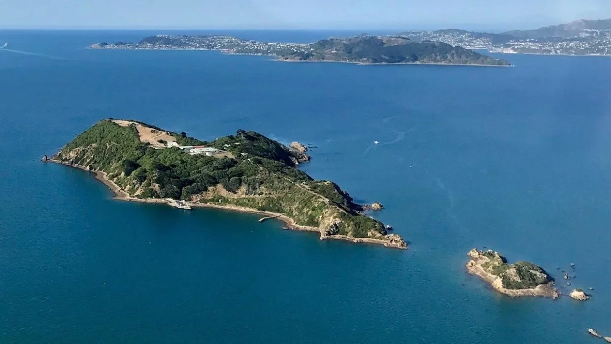
The three Harbour Islands
Mātiu/Somes, Makāro/Ward, and Mokopuna,
Wellington Harbour’s three islands
1. Mātiu/Somes Island
is located in some of the deepest waters in the harbour and is a haven for fishers who gather in numbers around the south side of the island. Makāro probably provides a small refuge for boaties from time to time. It sits in shallower water which extends across to the Eastbourne coast.
Matiu Somes Island is owned by local iwi (Taranaki Whānui) following a Treaty settlement. It is governed by a Kaitiaki Board and managed by DOC.
2. Mokopuna Island
is the smallest of the three Harbour Islands located to the north of Mātiu/ Somes and separated by a narrow channel of water. The island has been extensively replanted and is populated mainly by birds. It has no infrastructure and no public access.
3.Makāro/Ward Island
is a relatively barren rock with a growth of taupata (Coprosma repens) across its upper surfaces.
The island is a popular destination for recreational watercraft of all kinds
and the reefs and rocky coastline provide good fishing and snorkelling opportunities.

Ward Island in Wellington Harbour, New Zealand
Mākaro / Ward island is one of the three small islands in Wellington Harbour, at the southern end of the North Island, New Zealand.
Ward Island is on the eastern side of the harbour, about 1.7 kilometres (1.1 mi) west of the town of Eastbourne. It is about 250 metres (270 yd) long and 80 metres (87 yd) wide, with the long axis aligned north–south. The significantly larger Matiu / Somes Island lies about 5 km (3.1 mi) northwest.
Māori tradition is that both of these islands received their original Māori names from Kupe, the semi-legendary first navigator to reach New Zealand and get home again with reports of the new land, but this cannot be verified.
Makāro/ Ward Island is surrounded by shallower water and that shallow water extends to the Eastbourne shoreline.
Off the southern end lie beds of seaweed providing shelter for abundant fish life, and opportunities for collecting shellfish such as pāua and green-lipped mussels.

During the early 19th century the island provided a place of refuge for Ngāti Ira (a local Māori tribe) from other marauding tribes, and in World War II it was used as an anchor point for an anti-submarine /antishipping barrier to reduce the effective width of the harbour and make it more easily defensible should that need arise
Although today Makāro/Ward island is not occupied, in Māori times the island had a pā site on it and it is likely there is other evidence of Māori occupation. There has been planting on the island to assist in the restoration of its flora.

Wellington harbour.
Mokopuna Island foreground.
Pencarrow Head, harbour entrance and Miramar Peninsula behind,
Wellington, Wellington City District, Wellington Region, New Zealand (NZ).

Wellington Harbour aerial view, with Matiu Somes Island left.
Seaview, Point Howard, Eastern Bays and Remutaka (Rimutaka) Range behind,
Wellington, Hutt City District, Wellington Region, New Zealand (NZ)

Matiu/Somes Island looking south over Wellington Harbour


Matiu Somes Island in Wellington Harbour

Matiu/Somes Island, taken from Mt Kaukau, Khandallah, Wellington, New Zealand
Matiu / Somes Island is the largest of three islands in the northern half of Wellington Harbour, New Zealand. The island is 24.9 hectares (62 acres) in area, and lies 3 kilometres (1.9 mi) south of the suburb of Petone and the mouth of the Hutt River.

Matiu / Somes Island as seen from Normandale, Lower Hutt

Rock arch and raised platform at the northern tip of Matiu / Somes Island

Wellington City Centre and harbour from Mount Victoria

View of the Wellington Harbour from Mount Cook
Wellington
Te Whanganui-a-Tara (Māori)


Coat of arms
Nickname(s):
Windy Wellington, Wellywood

Motto(s):
Suprema a Situ
English: Supreme by position

Wellington, New Zealand, panorama view to the city from hillside of Oriental Bay

Seddon Statue in Parliament Grounds
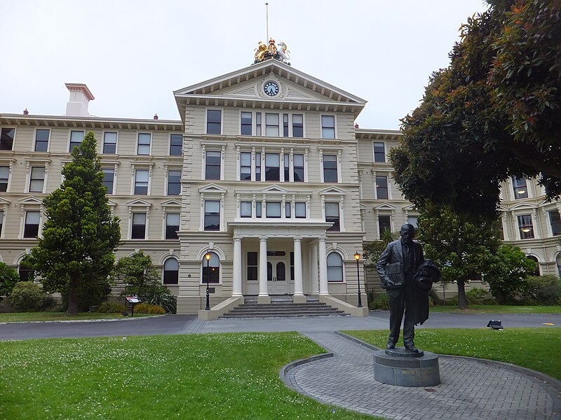
Entry to Old Government Buildings, Wellington, New Zealand

Wellington is the capital city of New Zealand. It is located at the south-western tip of the North Island, between Cook Strait and the Remutaka Range. Wellington is the third-largest city in New Zealand (second largest in the North Island), and is the administrative centre of the Wellington Region. It is the world's southernmost capital of a sovereign state. Wellington features a temperate maritime climate, and is the world's windiest city by average wind speed.
Māori oral tradition tells that Kupe discovered and explored the region in about the 10th century. The area was initially settled by Māori iwi such as Rangitāne and Muaūpoko. The disruptions of the Musket Wars led to them being overwhelmed by northern iwi such as Te Āti Awa by the early 19th century.

Civic Square
Wellington, New Zealand, February 2019

Te Papa
Papa Museum van Wellington.

Wellington's current form was originally designed by Captain William Mein Smith, the first Surveyor General for Edward Wakefield's New Zealand Company, in 1840. Smith's plan included a series of interconnected grid plans, expanding along valleys and lower hill slopes. The Wellington urban area, which only includes urbanised areas within Wellington City, has a population of 214,200 as of June 2024. The wider Wellington metropolitan area, including the cities of Lower Hutt, Porirua and Upper Hutt, has a population of 440,700 as of June 2024.
The city has served as New Zealand's capital since 1865, a status that is not defined in legislation, but established by convention; the New Zealand Government and Parliament, the Supreme Court and most of the public service are based in the city.

Historic_Wellington_Buildings
Landscape showing four historic buildings.
The en:National War Memorial (New Zealand) (Carillon lower left), en:New Zealand Dominion Museum building (copper-roofed building lower middle and lower right), en:Government House, Wellington (Edwardian building right middle) and en:Baring Head Lighthouse (on ridge upper left in far distance). Taken from the en:Victoria University of Wellington's Rankin-Brown building on the Kelburn campus.

Wellington Cable Car


Museum of New Zealand Te Papa Tongarewa

Zealandia Te Māra a Tāne
is the world’s first fully-fenced urban ecosanctuary with an extraordinary 500-year vision to restore the valley’s forest
and freshwater ecosystems as closely as possible to pre-human state.

Set around a picturesque reservoir, Zealandia Te Māra a Tāne is home to some of New Zealand's most rare
and extraordinary wildlife—all thriving wild in a world-first protected sanctuary.

Wellington Cable Car


Wellington Botanic Garden

Wellington Zoo


Wellington International Airport

Wellington – statue of Kupe Raiatea with his wife Te Aparangi
The bronze Kupe Group statue is located on Taranaki Street Wharf. It depicts Kupe Raiatea, the great Maori explorer and discoverer of Wellington harbour, his wife Te Aparangi and tohunga Pekahourangi. Wellington NZ.

Lambton Harbour, Port Nicholson ca. 1840
Lambton Harbour, Port Nicholson, Wellington, New Zealand, comprehending about one-third of the water frontage of the town of Wellington, ca. 1840, Charles Heaphy, from hand coloured lithographic print, engraved by JC Armytage, published by Smith Elder and Co, Cornhill, London, State Library of New South Wales,

Corner_of_Bowen_Street_and_Lambton_Quay,_circa_1929
Thorndon, the centre of government in Wellington, c. 1929.
The original Government House (now the site of the Beehive), Parliament Buildings and Turnbull House are in the background.
Wooden buildings are being demolished to make way for the construction of the Cenotaph. Government House, Parliament Buildings and Turnbull House are in the background. Photographer: Unknown (Wellington City Council archive reference: 00155:0:44) When the picture was taken, Bowen Street met with Lambton Quay about 60 metres north-east of where it is now - on the other side of the Cenotaph. The intersection was changed in the late 1930s as part of the work to extend Bowen Street to Tinakori Road, to help ease traffic congestion and shorten the route between the central city and Karori. The original end to Bowen Street existed until the early 1970s, when it was landscaped into the paved park between the Cenotaph and the gates to the Parliament grounds.

Government House – the residence of the Governor-General of New Zealand
South (front) entrance of the Government House in Newport, Wellington, New Zealand. Visiting dignitaries and other guests arrive at this front lawn.

St Mary of the Angels Catholic Church , Wellington, New Zealand

Apartments at Oriental Bay

Lambton Quay – Wellington's main street and the centre of economic and cultural activity
Buildings at Lambton Quay viewed from Featherston Street in Wellington, Wellington Region, North Island of New Zealand.

Cuba Street is considered the microcosm of Wellington's culture, being "quirky" and packed with retail and art, such as the Bucket Fountain (pictured).
The Wellington bucket fountain filled with flowers on 6 November 2018.

Victoria University's Kelburn campus, one of four in Wellington


Wellington hospital

Firth House, Wellington_college

Firth Hall, left, and the former College Hall, right
Wellington_college


Tararua Range & Rimutaka Hil

The Tararua Range, often referred to as the Tararua Ranges or Tararua, is one of several mountain ranges in the North Island of New Zealand.

Pasture_against_snow
Tararuas from Wairarapa
The Tararua Range runs northeast–southwest for 80 km (50 mi) from near Palmerston North to the upper reaches of the Hutt Valley, where the northern tip of the Remutaka Range begins. It is separated in the north from the southern end of the Ruahine Range by the Manawatū Gorge. Most of the Range is wilderness, protected as the Tararua Forest Park.
The highest peak in the Tararua Range is Pukeamoamo / Mitre (not to be confused with Mitre Peak) at 1,570 m (5,150 ft). Other prominent peaks include Mount Bannister at 1,537 m (5,043 ft) and Mount Hector at 1,529 m (5,016 ft), which is named after the scientist Sir James Hector. Its Māori name is Pukemoumou, or 'hill of desolation'.

Tararua Ranges behind the Hutt River in Autumn
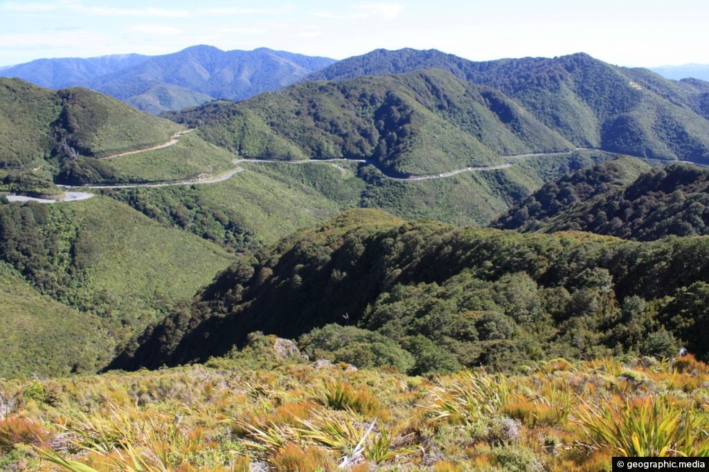
Remutaka Road, Remutaka Range
The Remutaka Range (spelled Rimutaka Range before 2017) is the southernmost range of a mountain chain in the lower North Island of New Zealand. The chain continues north into the Tararua, then Ruahine Ranges, running parallel with the east coast between Wellington and East Cape.
The 555-metre summit of the road over the range at its northern saddle is named Remutaka Pass. The pass was formally named on 17 December 2015.


Aerial Shot of the Rimutaka HIll

Remutaka hill road; tearooms at the summit.
Tearooms at the top of the Remutaka hill road in 1985.
The then 70-year-old tearooms were closed in 2008 and were hit by an arsonist in 2009;
they were then demolished, along with the toilet block.
A memorial to the 60,000 New Zealand troops who made the crossing over the hill
during the First World War was unveiled at the summit in 2015.

Rimutaka Hill march to war
250 March over Rimutakas
The trek from Featherston, in the Wairarapa, over the Rimutaka Hill to Upper Hutt,
was a rite of passage for about 60,000 soldiers bound for The Great War after completing their training.
The Remutaka Hill Road summit was officially renamed 'Remutaka Pass' on December 17, 2015;
'Rimutaka' was a mistaken spelling, and 'pass' was more appropriate than 'summit'.
Remutaka crossing memorial

Seventh Reinforcement marching over the Rimutaka Hill

Remutaka (Rimutaka) Hill Road (State Highway 2, SH2) climbing over the Remutaka (Rimutaka) Ranges (to 555m) from Upper Hutt to the Wairarapa. Aerial view on a moody evening, Remutaka, Upper Hutt City District, Wellington Region, New Zealand (NZ)


Remutaka Hill Road from the Summit, Looking East to the Wairarapa.
"'Sunset gilding' Rimutaka summit".
Taken from the hill road, looking east to the Wairarapa.
The Rimutaka Hill Road summit was officially renamed 'Remutaka Pass' on December 17, 2015;
'Rimutaka' was a mistaken spelling, and 'pass' was more appropriate than 'summit'.

Rimutaka Hill Road on the Wairarapa side.

Mt Climie Remutaka Range
Sub alpine view of the Remutaka Range looking south with Mt Climie visible.
Wellington, New Zealand


Wellington & Tararua Ranges
'Wonderful World' 카테고리의 다른 글
| Cloughoughter Castle in County Cavan, Ireland (0) | 2025.02.27 |
|---|---|
| Memorial Pictures of Welington and Wairarapa (0) | 2025.02.27 |
| Vaduz Castle, Liechtenstein (0) | 2025.02.27 |
| I'm a solo female traveller - these are my safety ratings for places I was told to avoid (0) | 2025.02.27 |
| 野柳地質公園 Yehliu Geopark 台湾新北市|北海岸景點 (0) | 2025.02.27 |