Sahara desert, of North Africa
From Wikipedia, the free encyclopedia

A 2002 satellite image of the Sahara by NASA WorldWind
Sahara desert, Morocco

Sahara in real color, calibrated and cropped from the original picture
The Sahara taken by Apollo 17 astronauts, 1972

Geographical map of the Sahara
Length: 4,800 km (3,000 mi)
Width : 1,800 km (1,100 mi)
Area : 9,200,000 km2 (3,600,000 sq mi)

An oasis in the Ahaggar Mountains. Oases support some life forms in extremely arid deserts.
Sand dunes in the Algerian Sahara

Sunset in the Sahara
The Sahara (/səˈhɑːrə/, /səˈhærə/) is a desert spanning across North Africa. With an area of 9,200,000 square kilometres (3,600,000 sq mi), it is the largest hot desert in the world and the third-largest desert overall, smaller only than the deserts of Antarctica and the northern Arctic.
The name "Sahara" is derived from Arabic: صَحَارَى, romanized: ṣaḥārā /sˤaħaːraː/, a broken plural form of ṣaḥrā' (صَحْرَاء /sˤaħraːʔ/), meaning "desert".
The desert covers much of North Africa, excluding the fertile region on the Mediterranean Sea coast, the Atlas Mountains of the Maghreb, and the Nile Valley in Egypt and the Sudan.
It stretches from the Red Sea in the east and the Mediterranean in the north to the Atlantic Ocean in the west, where the landscape gradually changes from desert to coastal plains. To the south it is bounded by the Sahel, a belt of semi-arid tropical savanna around the Niger River valley and the Sudan region of sub-Saharan Africa. The Sahara can be divided into several regions, including the western Sahara, the central Ahaggar Mountains, the Tibesti Mountains, the Aïr Mountains, the Ténéré desert, and the Libyan Desert.
For several hundred thousand years, the Sahara has alternated between desert and savanna grassland in a 20,000-year cycle[9] caused by the precession of Earth's axis (about 26,000 years) as it rotates around the Sun, which changes the location of the North African monsoon.

Village_Telly_in_Mali
Sahel region of Mali
Telly, one of the first villages in the Bandiagara escarpment in Mali.

The Great Green Wall,
participating countries and Sahel. In August 2023,
it was reported that the GGW had only covered 18% of the planned area.

The major topographic features of the Saharan region
Map showing major Dune seas (ergs) and Mountain ranges of the Sahara. Red dashed line shows approximate limit of the Sahara. National borders in grey. Dune seas in yellow. Derived from Blank map Image:Africa_topography_map_with_borders.png.

Ubari_Lakes_Luca_Galuzzi _ Libya
An Idehan Ubari oasis lake,
with native grasses and date palms
Ubari oasis - with lakes in Erg Awbari (Idehan Ubari) in the Sahara desert region of the Wadi Al Hayaa District, of the Fezzan region in southwestern Libya.
Oued Zouzfana and village of Taghit
Tashwinat Mummy

Beni Isguen, a holy city surrounded by thick walls in Ghardaïa, Mzab, the Algerian Sahara

Salzkarawane auf dem Weg von Agadez nach Bilma in Niger.
Azalai salt caravan. The French reported that the 1906 caravan numbered 20,000 camels.
Phoenicians : The people of Phoenicia, who flourished from 1200 to 800 BCE, created a chain of settlements along the coast of North Africa and traded extensively with its inhabitants. This put them in contact with the people of ancient Libya, who were the ancestors of people who speak Berber languages in North Africa and the Sahara today.
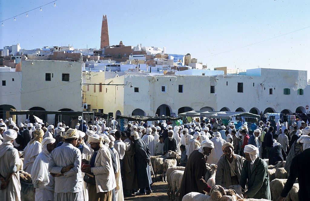
Market on the main square of Ghardaïa (1971)
Garamantes : An urban civilization, the Garamantes, arose around 500 BCE in the Sahara, in a valley that is now called the Wadi al-Ajal in Fezzan, Libya
Breakup of the empires and afterwards

A natural rock arch in south western Libya

The Sahara today
Egypt became independent of Britain in 1936, although the Anglo-Egyptian treaty of 1936 allowed Britain to keep troops in Egypt and to maintain the British-Egyptian condominium in the Sudan. British military forces were withdrawn in 1954.
Most of the Saharan states achieved independence after World War II: Libya in 1951; Morocco, Sudan, and Tunisia in 1956; Chad, Mali, Mauritania, and Niger in 1960; and Algeria in 1962. Spain withdrew from Western Sahara in 1975, and it was partitioned between Mauritania and Morocco. Mauritania withdrew in 1979; Morocco continues to hold the territory (see Western Sahara conflict).
Peoples and languages
Further information: Saharan languages, Saharan rock art, and Rock art § Sahara

A 19th-century engraving of an Arab slave-trading caravan transporting black African slaves across the Sahara
The people of the Sahara are of various origins. Among them the Amazigh including the Tuareg, various Arabized Amaziɣ groups such as the Hassaniya-speaking Sahrawis, whose populations include the Znaga, a tribe whose name is a remnant of the pre-historic Zenaga language. Other major groups of people include the: Toubou, Nubians, Zaghawa, Kanuri, Hausa, Songhai, Beja, and Fula/Fulani (French: Peul; Fula: Fulɓe). The archaeological evidence from the Holocene period has shown that Nilo-Saharan speaking groups had populated the central and southern Sahara before the influx of Berber and Arabic speakers, around 1500 years ago, who now largely populate the Sahara in the modern era.
Arabic dialects are the most widely spoken languages in the Sahara. Arabic, Berber and its variants now regrouped under the term Amazigh (which includes the Guanche language spoken by the original Berber inhabitants of the Canary Islands) and Beja languages are part of the Afro-Asiatic or Hamito-Semitic family.[citation needed] Unlike neighboring West Africa and the central governments of the states that comprise the Sahara, the French language bears little relevance to inter-personal discourse and commerce within the region, its people retaining staunch ethnic and political affiliations with Tuareg and Berber leaders and culture. The legacy of the French colonial era administration is primarily manifested in the territorial reorganization enacted by the Third and Fourth republics, which engendered artificial political divisions within a hitherto isolated and porous region. Diplomacy with local clients was conducted primarily in Arabic, which was the traditional language of bureaucratic affairs. Mediation of disputes and inter-agency communication was served by interpreters contracted by the French government, who, according to Keenan, "documented a space of intercultural mediation," contributing much to preserving the indigenous cultural identities in the region.
Sahara desert, Morocco

Sahara desert, Morocco
A big, barren band nearly the size of the United States stretches from the Atlantic to the Red Sea, bisecting the African continent. Though the sands of the Sahara seem older than time, their present state is younger than human civilization. Until it shifted south as recently as 4,200 BCE, heavy rains still fell on the Sahara—and one day, they will again. As the North African monsoon moves north and south on a cycle with the Earth's axis, it's estimated that in 10 or 15 millennia, the Sahara will start turning greener (though greenhouse gases could slow the process).
