2024. 8. 20. 05:01ㆍWonderful World

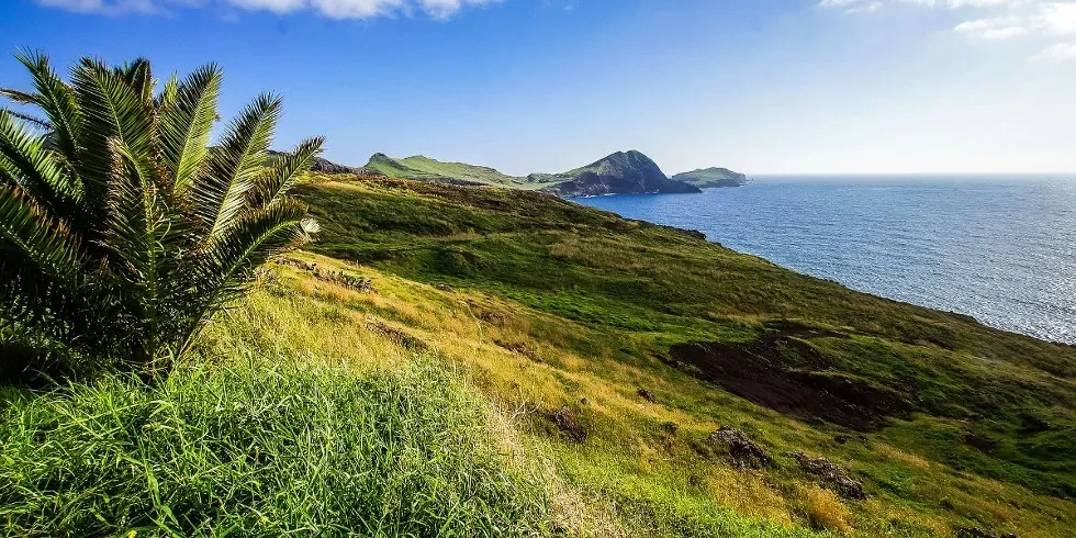
Ponta_de_São_Lourenço_north_north_east

Madeira (/məˈdɪərə/ mə-DEER-ə or /məˈdɛərə/ mə-DAIR-ə,[3][4][5] European Portuguese: [mɐˈðɐjɾɐ] ⓘ), officially the Autonomous Region of Madeira (Portuguese: Região Autónoma da Madeira), is one of two autonomous regions of Portugal, the other being the Azores. It is an archipelago situated in the North Atlantic Ocean, in the region of Macaronesia, just under 400 kilometres (250 mi) to the north of the Canary Islands and 520 kilometres (320 mi) west of the Kingdom of Morocco. Madeira is geologically located on the African Tectonic Plate, although it is culturally, politically and ethnically associated with Europe, with its population predominantly descended from the original Portuguese settlers. Its population was 251,060 in 2021. The capital of Madeira is Funchal, which is located on the main island's south coast.

Location-of-the-Ponta-de-Sao-Lourenco-peninsula-in-the-Eastern-tip-of-Madeira-Island

Eastern Madeira Island
Machico Municipality, Atlantic Ocean
Ponta de São Lourenço, Madeira, Portugal
Ponta de São Lourenço (Portuguese for the "Point of Saint Lawrence") is the easternmost point of the island of Madeira. It is inside the town of Caniçal and forms a part of the municipality of Machico. Its terrain are made up of rocks and herbaceous vegetation. Since 1982, the headland is a nature reserve, where it has the conservation of its endemic plants including Matthiola maderensis, Echium nervosum, and Andryala glandulosa, and it has fauna, including birds, insects, and molluscs. One of them is Monachus monachus, a seal. Marine fauna are in the waters surrounding the headland.

Ponta de São Lourenço, Madeira, Portugal. Heading north north east.
Ponta de São Lourenço from the vicinity of Machico
Northeast of the islet is Porto Santo, and southeast is Bugio and the Deserted Islands. Nearby are a few islets with the easternmost being Ilhéu do Farol (Farol Islet), where its nearby lighthouse is located.
The headland's highest point is Pico do Furado. There is a path which takes about an hour to walk from the headland entrance. To the west is the New Port of Madeira.
The headland's geology consists of pyroclastic rocks as well as basalt dykes (dikes) and some coasts being eroded. The group dates back to the Late Pleistocene, about 100,000 years ago

Ponta de São Lourenço from Baixas do Guincho, the vicinity of the island's new port

Ponta de São Lourenço, Madeira, Portugal
Even perched on Ponta de São Lourenço, this seaside lookout near Madeira's easternmost point, you'd be almost 600 miles from this nation's capital. An island territory of Portugal, Madeira boasts 90 miles of coastline alternating between sheer sea cliffs like these and inviting sandy beaches—welcoming experienced hikers, seasoned surfers, and champion beach nappers alike. The largest landmass in the Atlantic archipelago also called Madeira, it's a popular year-round destination for Europeans from chillier parts, particularly Great Britain and Germany.


Dragon’s tail view from Miradouro Ponta do Furado

ponta-de-sao-lourenco-walk-a-beautiful-hike-in-madeira

ponta-de-são-lourenço

Ponta de São Lourenço's Natural Reserve

Walk-Ponta-São-Lourenço

pointe-sao-lourenco


Ponta de Sao Lourenço Cruise, Caniçal -

Ponta de São Lourenço/Caniçal

vereda_da_ponta_de_sao_lourenco

Farol da Ponta de São Lourenço

Ilhéu da Ponta de São Lourenço

Tour de Barco Ponta São Lourenço

Madeira-hike-Miradouro-de-São-Lourenço-Cais-do-Sardinha-Pico-do-Furado


포르투갈의 마데이라섬의 폰타 데 사오 로렌꼬 Ponta de Sao Lourenço
폰타 데 사오 로렌꼬 Ponta de Sao Lourenço는 마데이라 섬의 동쪽 끝단에 자리하여 수려한 위엄을 보여준다
마데이라 섬은 모로코왕국 서쪽 520km, 북대서양에 위치한 군도로 포루투칼의 지방 자치주이다.
역사적으로도 통상 유럽과 신대륙을 잇는 무역로의 기항지 역할을...
유럽최고의 트레킹 코스로 알려진 ‘뽄따 드 싸옹 로렌쏘(Ponta de São Lourenço) 동쪽 끝
‘PR8 베르다 다 뽄따 드 싸옹 로렌쏘 (PR8 Vereda da Ponta de São Lourenço)
‘뽄따 드 싸옹 로렌쏘(Ponta de São Lourenço)'는 포르투갈어로 "세인트 로렌스의 지점[Point(곶)]"-- '성 호렌스 곶' 이라는 뜻이며 마데이라 섬의 가장 동쪽에 긴 꼬리처럼 달려있다.
카니샬(Caniçal) 마을에 있으며 마시코(Machico) 자치 단체의 일부를 형성한다. 그 지형은 암석과 초본 식물로 구성되어 있다. 1982년부터 곶(headland)은 자연보호구역으로 지정되어 Matthiola maderensis, Echium nervosa, Andryala Glandulosa 등 고유 식물을 보존하고 있으며 새, 곤충, 연체동물을 비롯한 동물군도 보유하고 있다.
그 중 하나가 물개인 Monachus monachus이다. 해양 동물군은 곶 주변 바다에 서식하고 있다.
Visting Madeira Island Portugal | Ponta de São Lourenço & Bica da Cana
https://www.youtube.com/watch?v=QN_ekiRRKX0&t=79s
'Wonderful World' 카테고리의 다른 글
| Nalta jute 10 Benefits of Jute Leaves (0) | 2024.08.20 |
|---|---|
| Castelo de Almourol in Portugalthe civil parish of Praia do Ribatejo (0) | 2024.08.20 |
| Castelo de Almourol in Portugalthe civil parish of Praia do Ribatejo (0) | 2024.08.19 |
| 鳥取砂丘 ( とっとりさきゅう) (0) | 2024.08.19 |
| 황산[黃山], 중국에서 가장 아름다운 산2 (0) | 2024.08.19 |