2024. 10. 4. 09:57ㆍWonderful World
Hindu Kush Mountain Range

Hindu kush mountains
The Hindu Kush (Pashto: هندوکش /kʊʃ, kuːʃ/ commonly understood to mean Killer of the Hindus, or Hindu-Killer) (Old name Uparisyena in Sanskrit which means beyond the reach of eagles) is an 800-kilometre-long (500 mi) mountain range in Central and South Asia to the west of the Himalayas that stretches through Afghanistan, from its centre to Northern Pakistan and into Tajikistan. The range forms the western section of the Hindu Kush Himalayan Region (HKH); to the north, near its northeastern end, the Hindu Kush buttresses the Pamir Mountains near the point where the borders of China, Pakistan and Afghanistan meet, after which it runs southwest through Pakistan and into Afghanistan near their border. The eastern end of the Hindu Kush in the north merges with the Karakoram Range. Towards its southern end, it connects with the Spin Ghar Range near the Kabul River. It divides the valley of the Amu Darya (the ancient Oxus) to the north from the Indus River valley to the south. The range has numerous high snow-capped peaks, with the highest point being Tirich Mir or Terichmir at 7,708 metres (25,289 ft) in the Chitral District of Khyber Pakhtunkhwa, Pakistan.

Hindu kush mountain range
The mountains have been associated with the legendary Alborz mountains of Iran in the Persian epic poem Shahnameh. The Hindu Kush range region was a historically significant centre of Buddhism, with sites such as the Bamiyan Buddhas. After conquest by the Sunni Caliphate a portion of the Hindu Kush known as Kafiristan, remained a stronghold of polytheistic sects until the 19th century, when it was renamed to Nuristan (land of light) by the Durrani Emirate. The range and communities settled in it hosted ancient monasteries, important trade networks and travellers between Central Asia and South Asia. The Hindu Kush range has also been the passageway during the invasions of the Indian subcontinent, and continues to be important during modern-era warfare in Afghanistan.

Tirich Mir 7,708 metres (25,289 ft) the highest peak
in the Hindukush Mountains of Chitral district of Pakistan.


The Hindu Kush mountains at the Afghanistan-Pakistan border

Panjshir Valley
The Valley of the Five Lions
(apt transliteration from the Persian “panjshir”, پنجشیر)

The Panjshir Valley (also spelled Panjsheer or Panjsher; Pashto/Dari: درهٔ پنجشير – Dare-ye Panjšēr; literally Valley of the Five Lions) is a valley in north-central Afghanistan, 150 kilometres (93 mi) north of Kabul, near the Hindu Kush mountain range.
It is divided by the Panjshir River. The valley is home to more than 100,000 people, including Afghanistan's largest concentration of ethnic Tajiks. In April 2004, it became the heart of the new Panjshir Province, having previously been part of Parwan Province.
The Panjshir Valley, has always been the only place Taliban never managed to set foot in, not even during the five years they were controlling the whole country from 1996 to 2001.

Economy and natural resources of Panjshir Valley

The Panjshir Valley (also spelled Panjsheer or Panjsher; Persian: درهٔ پنجشير - Dare-ye Panjšēr; literally Valley of the Five Lions) is a valley in north-central Afghanistan, 150 kilometres (93 mi) north of Kabul, near the Hindu Kush mountain range. Located in the Panjshir Province it is divided by the Panjshir River. The valley is home to more than 140,000 people, including Afghanistan's largest concentration of ethnic Tajiks. In April 2004, it became the heart of Panjshir Province.
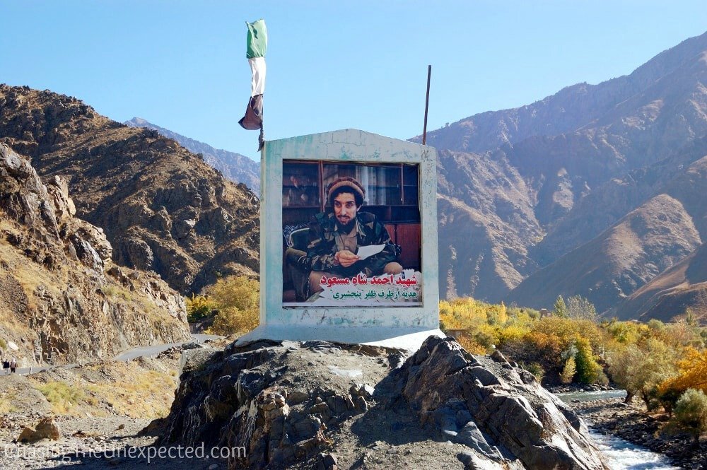
Pictures of Ahmad Shah Massoud all over the Panjshir Valley

The complex mausoleum, The final resting place of Ahmad Shah Massoud.

The Tomb of Massoud.
In the footsteps of Ahmad Shah Massoud in Afghanistan’s Panjshir Valley

The valley in front of the Panjshir River
The Panjshir Valley has the potential to become a major centre of emerald mining. As early as the 1st century AD, Pliny the Elder commented on gemstones from the region. In the Middle Ages, Panjshir was famed for its silver mining and the Saffarids and Samanids minted their coins there. As of 1985, emeralds upwards of 190 carats (38 g) had been found in Panjshir, reported to rival in quality the finest crystals of the Muzo mine in Colombia.
American reconstruction efforts in Afghanistan sparked a development boom in the valley with the construction of new modern roads and a new radio tower that allows valley residents to pick up radio signals from the Afghan capital, Kabul. The valley has the potential of being an energy hub for Afghanistan, through construction of several hydroelectric dams. Rewat locality could be the site of the first dam. The valley could make the capital region power self-reliant.
The Panjshir has always been an important highway. Nearly 100 kilometres (62 mi) long, it leads to two passes over the Hindu Kush – the Khawak Pass (3,848 m) leading to Afghanistan's northern plains, and the Anjuman Pass (4,430 m) that crosses into Badakhshan – used by the armies of Alexander the Great and Timur.
A 10-turbine wind farm was built in Panjshir Valley in April 2008.
Adventurous trip to Panjshir Valley
28,391 views
Dec 22, 2016
https://www.youtube.com/watch?v=9I6djRWVolQ
Discover Afghanistan - The Panjshir Valley
57,494 views
Mar 6, 2013
https://www.youtube.com/watch?v=-VzlEh0BvlU

The name AminPanjshir, literally meaning "Five Lions", refers to five Wali (literally, protectors), highly spiritual brothers who were centered in the valley. Local legend has it that the five brothers built a dam for Sultan Mahmud of Ghazni in the early 11th century AD. The foundations serve today for a modern reservoir.

The Beautiful Panjshir Valley, Afghanistan
'Wonderful World' 카테고리의 다른 글
| 부산에서 고성까지~ 해파랑길따라 (0) | 2024.10.04 |
|---|---|
| 굽이굽이 숨겨진 '화암팔경'…굽이진 인생을 위로하다 (0) | 2024.10.04 |
| Pamir Mountains & Pamir Highway Wakhan (0) | 2024.10.04 |
| Welcome to Kyrgyzstan! Добро пожаловать в Кыргызстан! (0) | 2024.10.04 |
| 'World In Union' (0) | 2024.10.04 |