2024. 10. 12. 05:06ㆍWonderful World

드라켄즈버그 산맥 Drakensberg Mountains
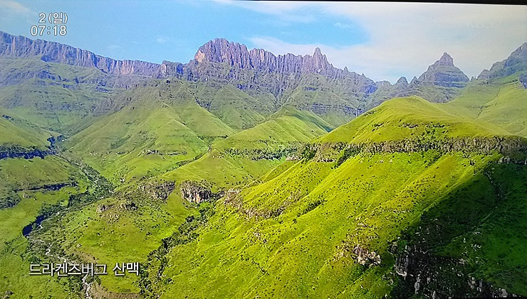
남아프리카에서 가장 높은 산맥으로 최고봉은 타바나누토레냐나산(해발 3,482m)이다.
이 산은 레소토 국내 정점이기도 하다.
"드라켄즈버그"는 아프리칸스어로 "용의 산"을 의미하고, 줄루어로 우쿠하란바( "창 장벽")로 불린다.

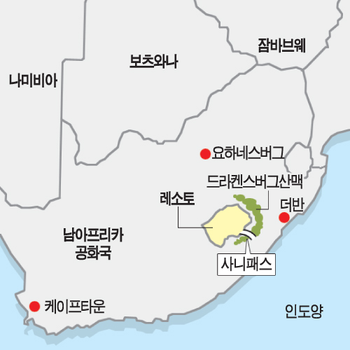
크와줄루 나탈 국가와 프리 스테이트를 분리하는 산이며, 그 북서 코드 부분은 남아프리카 공화국과 레소토의 국경을 형성하고 있다. 레소토 영토 내에 위치하는 것은 《말루티 산맥》(Maluti Mountains)으로 불린다.

이 산맥은 남아프리카 공화국 동부에 위치하고, 남서에서 북동으로 약 1,125km에 걸쳐 뻗어 있으며, 3,000미터 이상의 높은 봉우리가 많다. 흔히 생각하는 희망봉 쪽에 위치하는 산맥으로, 산맥이 해안을 둘러싸는 양상을 보인다고 할 수 있다.
서부는 오렌지 강과 바르 강에 침식되어 있으며, 동부와 남부에는 투게라 강을 비롯한 많은 강이 흐르고 있다.
남아프리카 공화국, 나미비아, 보츠와나, 에스와티니 등을 지나며, 남아프리카 최남단에 위치하고 있으므로 남극과도 꽤 가깝고 대서양, 인도양에 맞닿고 있다.

GiantsCastlePanoramaSmall
자이언트 캐슬 지역의 파노라마
Panorama of the KwaZulu-Natal Drakensberg, from the vicinity of Giant's Castle, on left and just out of sight, through to Cathkin Peak at far right, a direct distance of 31 kilometres (19 mi). From left to right are the Long Wall, Katana, the Carabineers ending in a hidden valley, Kambule, Mt. Durnford – a table head with Jareteng and Potterill in its foreground (above green knoll), Erskine, Langalibalele Pass (somewhat obscured) and The Thumb at the top of a firebreak. Centrally placed are the Bannerman Face, Bannerman Pass, and the angular Gypaëtus Point. To its right the gradual cline upwards to Popple Peak, The Judge and The Corner. To the right, in blue haze, the extensive Injasuti region, followed by Champagne Castle, the pointed Monk's Cowl and Cathkin Peak.
'Wonderful World' 카테고리의 다른 글
| New Zealand Crisis Live: Massive Earthquake Hits Wellington As Nation Deals With Cyclone Aftermath (0) | 2024.10.12 |
|---|---|
| Poverty rates in rich countries: New Zealand's ranking revealed (0) | 2024.10.12 |
| 물이 만들어내는 아름다운 장관 (6) | 2024.10.12 |
| 특색 있는 해변 (2) | 2024.10.12 |
| 영취산 (靈鷲山) 통도사 (通度寺)의 봄 (2) | 2024.10.12 |