2024. 10. 25. 04:19ㆍWonderful World
. 잠비아라는 이름은 이 나라의 남쪽 국경선을 따라 흐르는 잠베지강으로부터 유래했다.

잠베지 강
Zambezi River, Zambeze River, Zambesi River
잠비아의 칼렌 구릉 부근에 있는 해발 약 1,460m의 수원에서 S자 모양의 이중호를 그리며 남쪽으로 흘러 앙골라·잠비아 서부를 지난 다음 북동쪽으로 잠비아·짐바브웨 국경을 이루며 흐르다가 남동쪽으로 모잠비크를 가로질러 인도양에 면한 삼각주로 들어간다. 카봄포·룽궤붕구·초베·카푸에·시레 강 등이 주요지류이다.
잠베지 강에는 아프리카의 다른 강들과 마찬가지로 모래톱들이 하구를 가로막고 있으며, 수심이 얕고 급류와 폭포들이 있다. 잠베지 강에는 빅토리아 폭포의 다리, 카리바 댐의 제방, 짐바브웨의 치룬두에 있는 다리, 모잠비크의 빌라노바다프론테이라와 빌라데세나 사이의 다리 등이 있다. 강 연안에는 로지족·통가족·쇼냐족·체와족·은셍가족 등이 살고 있다.
중앙 아프리카 고원의 발원지에서 동쪽으로 흘러 인도양으로 들어간다.
잠비아의 칼렌 구릉 부근에 있는 해발 약 1,460m의 수원에서 S자 모양의 이중호(弧)를 그리며 남쪽으로 흘러 앙골라와 잠비아 서부를 지난 다음 북동쪽으로 잠비아·짐바브웨 국경을 이루며 흐르다가 남동쪽으로 모잠비크를 가로질러 인도양에 면한 삼각주로 들어간다. 주요지류로는 카봄포·룽궤붕구·초베·카푸에·시레 강 등이 있다. 잠베지 강 유역은 대륙의 중남부지역 전체에 걸쳐 있다.
잠비아와 앙골라를 가로지르는 상류에서 이 강은 해발 약 300m이며, 크고 작은 10여 개의 지류를 받아들인다. 해발 880m인 잠비아의 카중굴라에서 강의 너비는 1,380m로 최대에 달하며, 호탕하게 흐르는 물이 빅토리아 폭포 아래로 떨어진다. 잠베지 강은 약 720km에 걸쳐 잠비아와 짐바브웨의 국경을 이루며, 이 수역 가운데 약 280km는 카리바 댐의 건설로 조성된 저수지인 카리바 호가 차지한다.
모잠비크 국경 부근의 중류에서 강은 카보라바사 댐에 의해 조성된 약 320km 길이의 카보라바사 저수지로 들어간다. 하류에서 잠베지 강은 테테 분지로 들어가 루파타 협곡을 통과한 다음 모잠비크 평원으로 빠져나오며, 이 평원에서 강은 여러 곳에서 너비가 5~8km로 퍼지는 넓은 하곡을 이룬다. 빌라폰테스 부근에 이르면 마지막으로 큰 지류인 시레 강이 합류한다.
하구에서 잠베지 강은 모래톱에 의해 가로막히는 넓고 평탄한 소택성의 삼각주로 갈라져 들어간다. 먼저 2개의 수로로 크게 갈라지고, 각 수로가 다시 2개로 갈라진다. 보다 넓은 동쪽 수로는 북쪽의 무셀로 강과 남쪽의 잠베지 강의 본류 하구로 갈라진다. 서쪽 수로는 인하미센고 강과 보다 작은 멜람베 강을 형성한다.
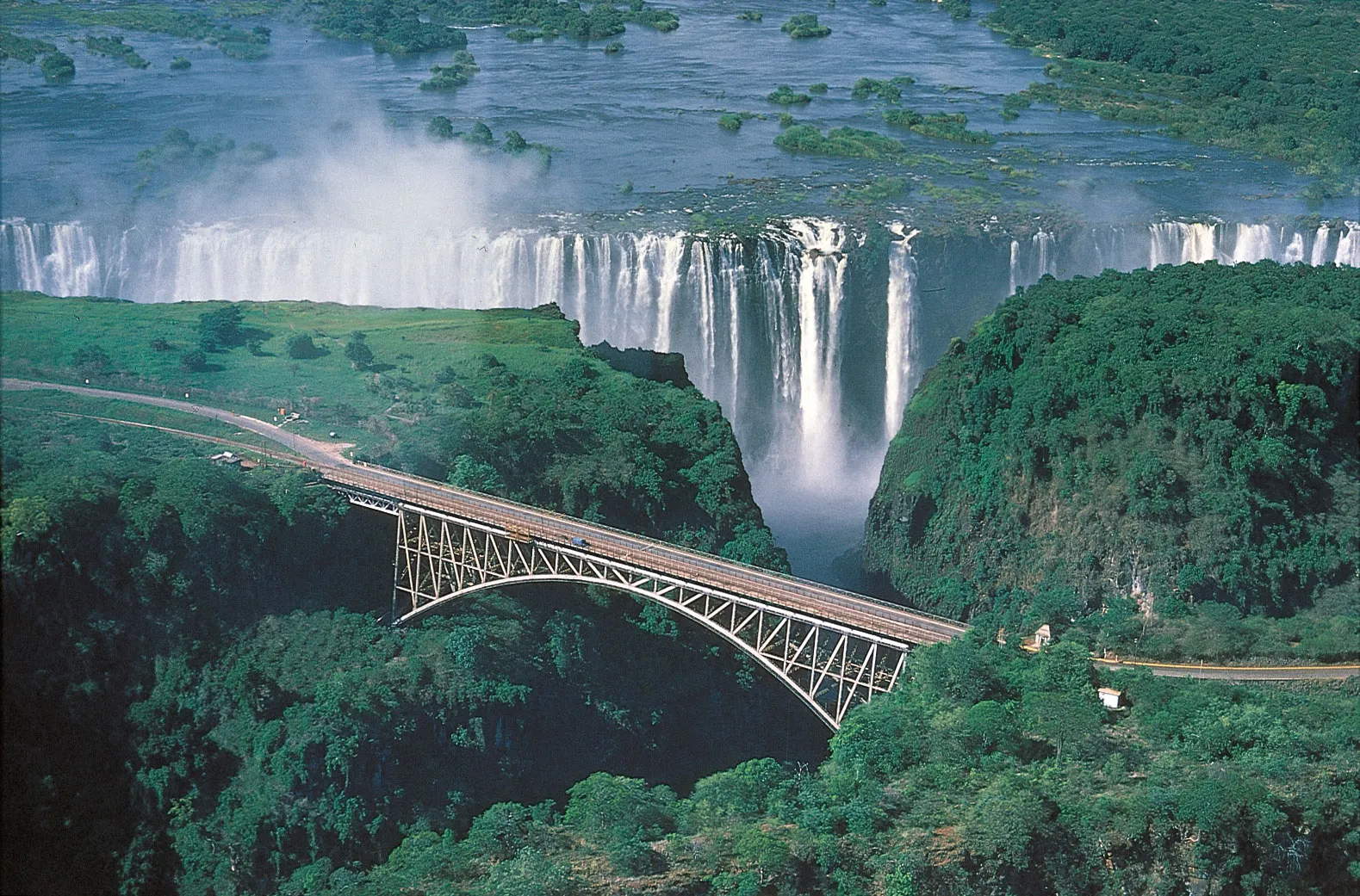
잠베지 강에도 아프리카의 다른 강들에서 볼 수 있는 것과 같은 종류의 천연 장애물들이 있다. 즉 모래톱들이 하구를 가로막고 있으며, 수심이 얕고, 급류와 폭포들이 있다. 전체길이 가운데 약 2,600km는 흘수가 얕은 증기선이 다닐 수 있다. 잠베지 강에는 4개의 주요한 건널목이 있다. 빅토리아 폭포의 다리, 카리바 댐의 제방, 짐바브웨의 치룬두에 있는 다리, 모잠비크의 빌라노바다프론테이라와 빌라데세나 사이의 다리 등이다.
카리바 협곡에서 잠베지 강을 막아 수력발전을 이루는 카리바 댐이 있고, 카리바 호는 그 댐으로부터 악마의 협곡까지 280km에 걸쳐 있다. 이 호수는 최대너비가 32km에 달한다. 잠베지 강 연안에는 로지족(바로체족)·통가족·쇼냐족·체와족·은셍가족을 포함하여 많은 종족이 살고 있다.

Zambezi_River_at_junction_of_Namibia,_Zambia,_Zimbabwe_&_Botswana
The Zambezi (also spelled Zambeze and Zambesi) is the fourth-longest river in Africa, the longest east-flowing river in Africa and the largest flowing into the Indian Ocean from Africa. Its drainage basin covers 1,390,000 km2 (540,000 sq mi), slightly less than half of the Nile's. The 2,574-kilometre-long (1,599 mi) river rises in Zambia and flows through eastern Angola, along the north-eastern border of Namibia and the northern border of Botswana, then along the border between Zambia and Zimbabwe to Mozambique, where it crosses the country to empty into the Indian Ocean.
The Zambezi's most noted feature is Victoria Falls. Its other falls include the Chavuma Falls at the border between Zambia and Angola, and Ngonye Falls near Sioma in western Zambia.
The two main sources of hydroelectric power on the river are the Kariba Dam, which provides power to Zambia and Zimbabwe, and the Cahora Bassa Dam in Mozambique, which provides power to Mozambique and South Africa. Additionally, two smaller power stations are along the Zambezi River in Zambia, one at Victoria Falls and the other in Zengamina, near Kalene Hill in the Ikelenge District.

Map of the Zambezi, with national boundaries
Zambezi - Wikipedia
Major river in southern Africa Zambezi RiverZambesi, ZambezeThe Zambezi River at the junction of Namibia, Zambia, Zimbabwe and BotswanaNickname(s)BesiCountriesSourceMain stem source. Zambezi Source National Forest • locationIkelenge District, North-Wes
en.wikipedia.org
Origins

The Zambezi and its river basin
The river rises in a black, marshy dambo in dense, undulating miombo woodland 50 km (31 mi) north of Mwinilunga and 20 km (12 mi) south of Ikelenge in the Ikelenge District of North-Western Province, Zambia, at about 1,524 metres (5,000 ft) above sea level. The area around the source is a national monument, forest reserve, and important bird area.
Eastward of the source, the watershed between the Congo and Zambezi Basins is a well-marked belt of high ground, running nearly east–west and falling abruptly to the north and south. This distinctly cuts off the basin of the Lualaba (the main branch of the upper Congo) from the Zambezi. In the neighborhood of the source, the watershed is not as clearly defined, but the two river systems do not connect.
The region drained by the Zambezi is a vast, broken-edged plateau 900–1,200 m high, composed in the remote interior of metamorphic beds and fringed with the igneous rocks of the Victoria Falls. At Chupanga, on the lower Zambezi, thin strata of grey and yellow sandstones, with an occasional band of limestone, crop out on the bed of the river in the dry season, and these persist beyond Tete, where they are associated with extensive seams of coal. Coal is also found in the district just below Victoria Falls. Gold-bearing rocks occur in several places.

Zambezi_river


Zambezi River in Batoka Gorge below Victoria Falls, Zimbabwe / Zambia Border


victoria-falls-aerial-batoka-gorge
Zig zagging gorge after the waterfall

Victoria_Falls_gorge


Victoria_Falls_aerial_view

View of the Middle Zambezi

zambezi-rive


Victoria Falls, Zambia and Zimbabwe

Victoria-Falls-bridge-Zambezi-River-Zimbabwe-Zambia


Wildlife in Lower Zambezi National Park - Zambia
The Big Four (lion, elephant, buffalo, leopard)

Elephants cross the Zambezi River between Zimbabwe and Zambia

A crocodile shows off its teeth while lounging on the Zambezi River at the border between Zambia and Zimbabwe.

Lower Zambezi river safari

'Wonderful World' 카테고리의 다른 글
| Matinloc Island, El Nido, Phillipines (3) | 2024.10.25 |
|---|---|
| Bromo Tengger Semeru National Park, Indonesia (0) | 2024.10.25 |
| 10 most beautiful UNESCO parks in Europe. (1) | 2024.10.25 |
| Benagil Cave of Lagoa, Algarve, in Portugal (0) | 2024.10.25 |
| Ilha de São Miguel, Açores, Portugal (1) | 2024.10.25 |