2024. 11. 11. 03:34ㆍWonderful World

Moorea
The Magical Island

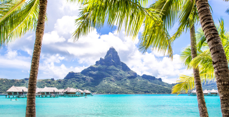
Believed to have inspired the mythical Bali Hai from James Michener's Tales of the South Pacific, Moorea is one of the most scenically striking islands in French Polynesia. Despite her immaculate beauty, she is far from unapproachable. Possessing a relaxed vibe and welcoming spirit, Moorea is just as warm and inviting as the Tahitians lucky enough to call this island home.

Mo'orea
Island in the Pacific Ocean

Moorea, French Polynesia


Moʻorea, view from the sky (Motu Fareona)
Mo'orea
Island in the Pacific Ocean
Moʻorea (English: /ˌmoʊ.oʊˈreɪ.ɑː/ or /ˈmoʊ.oʊreɪ/; Tahitian: Moʻoreʻa, [moʔore(ʔ)a]), also spelled Moorea, is a volcanic island in French Polynesia. It is one of the Windward Islands, a group that is part of the Society Islands, 17 kilometres (11 mi) northwest of Tahiti.

Motu is, local name about Sand Island with vegetation, Situated in the external edge of the coral reef surrounding the Main central Island . The lagoon is situated between The coral Barrier/Motu and the main mountain's island
The name comes from the Tahitian word Moʻoreʻa, meaning "yellow lizard": Moʻo = lizard; Reʻa (from reʻareʻa) = yellow. An older name for the island is ʻAimeho, sometimes spelled ʻAimeo or ʻEimeo (among other spellings that were used by early visitors before Tahitian spelling was standardized). Early Western colonists and voyagers also referred to Moʻorea as York Island or Santo Domingo.
The island had a population of 14,226 inhabitants in the 2002 census which increased to 17,718 in 2017, distributed in the associated communes of Afareaitu, Haʻapiti, Paopao, Papetōʻai, and Teavaro. Together with Maiʻao it forms the commune of Moʻorea-Maiʻao, which had 14,550 inhabitants by 2002.

Geography
The island was formed as a volcano 1.5 to 2.5 million years ago, the result of the Society hotspot in the mantle under the oceanic plate that formed the whole of the Society Archipelago. It is theorized that the current bays were formerly river basins that filled during the Holocene searise.
Moʻorea is about 16 km (10 miles) across. There are two small, nearly symmetrical bays on the north shore. The one to the west is called ʻŌpūnohu Bay. The main surrounding communes of the bay are Pihaʻena in the east and Papetōʻai to the west. The one to the east is Cook's Bay, also called Pao Pao Bay since the largest commune of Moʻorea is at the bottom of the bay. The other communes are Pihaʻena to the west and busy Maharepa to the east.

Mount Tohivea (Mont Tohiea), Moʻorea
The highest point is Mount Tohivea, near the center of Moʻorea. It dominates the vista from the two bays and can be seen from Tahiti. There are also hiking trails in the mountains. Vaiʻare Bay is another small inlet, smaller than the two main bays, on the east shore. The main village is located just south of the bay.
Bays


Sunset in Moʻorea
The most famous sight of Moʻorea is Cook's Bay, where cruise ships regularly anchor. It is a deep blue bay that often has white sailing yachts and in the background the 830 m high Mount Mouaputa, this being probably the most photographed South Seas image. Next door is Opunohu Bay, where many exterior shots of the 1984 movie The Bounty were filmed.

Cook's Bay

Opunohu Bay.
The two bays are connected by a steep, winding scenic road. In the once densely populated Opunohu Valley, the indigenous Polynesians built numerous worship platforms (marae). The remains of these religious sites can be found everywhere off the road, some of them are signposted. Marae Titiroa is surrounded by banyan trees and was reconstructed in the late 1960s. A few hundred meters away is the multi-level Marae Ahu-o-Mahine, also well preserved. The trail continues to the Belvédère lookout overlooking Mount Rotui, Cook Bay and Opunohu Bay.

A shark (Carcharhinus melanopterus) in Moʻorea
Politics
The island is administratively part of the commune (municipality) of Moʻorea-Maiʻao, itself in the administrative subdivision of the Windward Islands. The main village is ʻĀfareaitu. The largest village is Pao Pao at the bottom of Cook's Bay. The second largest is Maharepa.
This island is one of the main tourist destinations in French Polynesia, where there are several luxury resorts.
Transportation to this island is usually done from Tahiti by air transport in flights of about 5 minutes or through numerous ferries that move from the port of Papeʻete to Moʻorea. It is also possible to hire a private boat transport.

Bungalows of Hotel Hibiscus, Haurū Point, Moʻorea

Pineapple farming in Moʻorea

Church of the Holy Family in Haʻapiti (Église de la Sainte-Famille)
Catholic Church of the Holy Family in Haapiti, Moorea, Society Islands, French Polynesia
무레아산
폴리네시아의 섬 Moorea


tahiti-and-moorea-road-map


Lagoon Views of Moorea

Belvedere Lookout Point, Moorea

ATV Excursion on Moorea


'Wonderful World' 카테고리의 다른 글
| Francois Peron National Park, Western Australia (0) | 2024.11.15 |
|---|---|
| Bonsai Rock, Lake Tahoe, Washoe County, Nevada (2) | 2024.11.12 |
| Lençóis Maranhenses National Park, Brazil (1) | 2024.11.10 |
| Snow falls for the first time ever in desert in Saudi Arabia (1) | 2024.11.09 |
| 日本 / 日光東照宮 (1) | 2024.11.09 |