2024. 11. 28. 09:06ㆍWonderful World
The 1st,2nd,3rd Tallest Mountain and 4th on Earth.

Where are they?©Rainer Lesniewski/Shutterstock
The Himalayas extend for around 1,550 miles (2,500km) between the peak of Nanga Parbat in Pakistan-administered Kashmir and the peak of Namjagbarwa (Namcha Barwa) in Tibet. With a total area of roughly 230,000 square miles (595,000sq km) they mostly lie in India, Nepal and Bhutan, with China and Pakistan occupying parts of them.
히말라야는 파키스탄령 카슈미르의 낭가파르바트 정상과 티베트의 남작바르와(Namcha Barwa) 정상 사이에 약 2,500km에 걸쳐 펼쳐져 있습니다. 총 면적은 약 595,000평방킬로미터(230,000평방마일)에 달하며 대부분 인도, 네팔, 부탄에 위치하고 있으며, 중국과 파키스탄이 일부를 차지하고 있습니다.
The 1st,2nd,3rd Tallest Mountain and 4th on Earth
8,516m
The 4th Tallest Mountain on Earth?

세계 4위봉 로체(Lhotse)는 티베트어로 남봉(南峰)이라는 뜻입니다.
로(Lho)는 ‘남’, 체(tse)는 ‘봉’, 즉 ‘에베레스트 남쪽에 있는 봉우리’라는 뜻이니,
실제로 로체는 에베레스트에서 남쪽으로 불과 3km 지점에 위치해 있습니다.

.
Lhotse, just south of Everest on the border between Tibet and Nepal, is the third highest mountain in the Himalayas at 27,940 feet (8,516m) and the fourth highest mountain in the world. Since it’s joined to Everest by a 25,000-foot (7,600m) high ridge, it’s sometimes considered part of the Everest Massif, with mountaineers who scale it following the same route for much of the way.
티베트와 네팔 국경에 있는 에베레스트 남쪽의 로체산은 히말라야에서 세 번째로 높은 산으로 해발 27,940피트(8,516m)로 세계에서는 네 번째로 높은 산입니다. 7,600m(25,000피트) 높이의 능선으로 에베레스트와 연결되어 있기 때문에 때때로 에베레스트 산괴의 일부로 간주되며 산악인들은 대부분 같은 경로를 따라 이 산을 오릅니다.
8,586m
The 3rd Tallest Mountain on Earth?

Standing at an eye-watering 28,169 feet (8,586m) tall, Kanchenjunga is the third highest mountain on Earth. It’s located in the eastern part of the mountain range on the Nepal-India border. Although shorter than Everest, it’s considered a more treacherous climb since less is known about it – just around 20-25 people attempt to summit each year compared to the 650-plus that climb Everest.
눈길을 사로잡는 8,586m(28,169피트) 높이의 칸첸중가(Kanchenjunga)는 지구상에서 세 번째로 높은 산입니다.
네팔-인도 국경 산맥의 동쪽 부분에 위치하고 있습니다. 에베레스트보다 낮지만 알려진 바가 적기 때문에 더 위험한 등반으로 간주됩니다.
에베레스트를 오르는 650명 이상의 사람에 비해 매년 약 20~25명의 사람이 정상에 오르려고 시도합니다.

네팔과 인도의 국경에 위치한 8,000m가 넘 산- 다섯 개의 봉우리를...
세계 3위 고봉인 칸첸중가(Kangchenjunga)는
티베트어로 칸(Kang)은 ‘눈’, 첸(chen)은 ‘크다’, 주(Ju)는 ‘보고’, 가(nga)는 ‘다섯’이라는 뜻을 가지고 있습니다.
즉 ‘큰 눈의 다섯 개 보고’라는 의미.
칸첸중가는 그 이름이 뜻하듯 주봉·중앙봉·남봉·서봉(얄릉캉)·캉바첸 등 다섯 개의 봉우리가 모여서 이루어진 대산괴입니다. .
8,611m
The 2nd Tallest Mountain on Earth?

K2는 공식 명칭을 얻지는 못했지만 '산의 왕'을 의미하는 초고리(Chhogori)라는 고유 이름을 갖고 있었습니다.
에베레스트에 이어 두 번째로 높은 산인데 등반은 더 어렵다고 알려져 있습니다.
라체델리아와 아킬레 콤파그노니가 최초로 등정에 성공했고
두 번째 등정은 23년 후 1977년 일본 원정대에 의해 이루어졌고
무려 1,500명이 넘는 짐꾼들이 동원되었다는 기록이 있습니다.
K2
고드윈오스턴 산
8,611m

세계에서 두 번째로 높은 산은 'K2'로 세계 최고봉 에베레스트와 같은 히말라야산군입니다.
카라코람 산맥에 속하며 부분적으로는 파키스탄이 관리하는 카슈미르의 길기트-발티스탄 지역, 부분적으로는 중국이 관리하는 신장 타지크족 자치현의 트랜스-카라코람 지역에 속한다.
"It's a savage mountain that tries to kill you."
K2는 1953년 미국 원정대의 등반가인 조지 벨이 "당신을 죽이려는 야만적인 산이다"라고 말한 이후 새비지 산(Savage Mountain)으로 알려지게 되었다.

K2: The King of Mountains
K2 is quite often called “The Mountaineers’ Mountain,”
K2: 산의 왕
K2는 흔히 "산악인의 산"으로 불립니다.
K2는 1856년 하라무크산에 섰던 T.G.몽고메리 라는 젊은 중위에 의해 "Karakoram 2"로 명명되었으며.
그의 간단한 스케치는 카라코람 산맥의 가장 눈에 띄는 두 봉우리를 "K1"과 "K2"로 자세히 설명했습니다.
The 1st, Tallest Mountain on Earth
정확한 높이를 아는 사람은 아마도 없을 것~...
해마다 산이 솟아 자라나고 있다니...

Guardian
Tue 8 Dec 2020 12.30 GMT
네팔과 중국은 양국의 측량 결과를 교환하고 최고봉의 높이로 8,848.86 metres (29,032ft) 공식 합의했다.
티베트어로 초모랑마로 알려진 에베레스트 산은 주변에
6개의 8,000미터 급 봉우리와
30개의 7,000미터 급 봉우리를 거느리고...
1953년 5월 29일
뉴질랜드사람 에드먼드 힐러리 와
네팔인 세르파, 텐징 노르가이 가
남동쪽 능선을 타고 남봉을 지나 정오 무렵 정상에 올랐답니다.
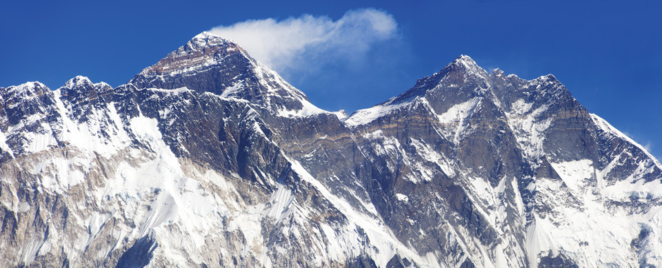
With its summit a dizzying 29,032 feet (8,849m) above sea level, Mount Everest is the highest mountain on Earth. Everest, however, is not its only name. Straddling the border between Nepal and Tibet, the mountain is known as Sagarmatha in Sanskrit, meaning "peak of heaven", and Chomolungma in Tibetan, meaning "goddess of the valley". It was named Everest in 1865 after the British surveyor general of India, Sir George Everest.
정상이 해발 8,849m(29,032피트)에 달하는 에베레스트 산은 지구상에서 가장 높은 산입니다. 그러나 에베레스트가 유일한 이름은 아닙니다. 네팔과 티베트의 국경에 걸쳐 있는 이 산은 산스크리트어로 "하늘의 봉우리"를 의미하는 사가르마타, 티베트어로 "계곡의 여신"을 의미하는 초모룽마로 알려져 있습니다. 1865년 영국의 인도 측량 장군인 조지 에베레스트 경의 이름을 따서 에베레스트로 명명되었습니다.
Everest
8,848.86m

네팔과 티베트의 국경에 걸쳐 있는 지상 최고봉 이름은 에베레스트가 유일한 이름만은 아닙니다.
1865년 영국의 인도 측량 총감, 조지 에베레스트 경의 이름을 따서 에베레스트로 명명되었지만,
티베트어로는 ‘계곡의 여신’ 혹은 ‘지구의 모신’이라는 뜻의 초모룽마(Chomolungma 또는 Jomolungma)이며
네팔어로는 ‘눈의 여신’이라는 뜻의 사가르마타(Sagarmatha),
산스크리트어로 "하늘의 봉우리"를 의미하는 사가르마타,
중국에서는 추랑랑마(珠穆朗瑪)라고 칭한답니다.
1852년 영국의 인도 측량국에서 히말라야 고봉들을 백 수십 km 떨어진 벵골평야의 6개 기점에서 측량해 세계 최고봉임을 확인했다. 최초 측정 높이는 8,840m이며, 1954년 8,848m로 측량된 수치가 공식 높이로 여겨지고 있었다.
8,848.86m
In December 2020 a new height for Everest was agreed.
The summit of Mount Everest was confirmed to be 8,848.86m above sea level (8,849m, if you’re rounding)
Guardian News & Media Limited
Tue 8 Dec 2020 12.30 GMT
Kathmandu and Beijing had differed over its exact height, but after each sent an expedition of surveyors to the summit they have agreed that the official height is 8,848.86 metres (29,032ft), a bit more than their previous calculations.

The explorer Sir Edmund Hillary
New Zealand five-dollar banknote
1953년 영국등반대의 에드먼드 힐러리와 세르파 텐징 노르게이 초등했다.
한국에서는 1977년 고상돈이...
Mount Everest: China and Nepal agree on new, taller height
Guardian News & Media Limited
Tue 8 Dec 2020 12.30 GMT
Countries have settled on 8,848.86m – higher than either’s previous measurements
Mount Everest is marginally higher than previously thought, according to a new joint Chinese-Nepali calculation that settles a long-running conflict over the height of the world’s tallest peak, which straddles the countries’ shared border.
Kathmandu and Beijing had differed over its exact height, but after each sent an expedition of surveyors to the summit they have agreed that the official height is 8,848.86 metres (29,032ft), a bit more than their previous calculations.
Nepal previously relied for its measurement on an estimate of 8,848 metres made by the Survey of India in 1954, which included snow lying in the rock summit pyramid. This was for a long time regarded as the “official” height.
A Chinese measurement in 2005 determined that the rock height of the summit – known as Chomolungmu and Sagarmartha in local languages - was 8,844.43 metres (29,017 feet), about 3.7 metres (11 feet) less than the 1954 estimate.
Everest is named after the colonial-era British surveyor George Everest, who never actually saw it. The new measurement will have little practical impact. K2, the world’s second highest mountain, is 237 metres lower.
The reason why the newly agreed figure may be temporary is because the 2,900km-long Himalayan chain is located on, and was formed by, the uplift caused by the colliding Indian and Eurasian tectonic plates, which are continuing to push up the Himalaya at an average of 1cm every year.
Nepal, which is home to another seven of the world’s 14 highest peaks, sent its first team of surveyors in May last year to measure Everest. Government officials told the BBC eight years ago that they felt under pressure from China to accept the Chinese height and therefore they had decided to go for a fresh measurement to “set the record straight once and for all”.
Chinese surveyors then climbed the peak in spring this year, when the mountain was closed by both countries for other climbers due to the coronavirus pandemic.
Damodar Dhakal, spokesman for Nepal’s department of survey, said the Nepali surveyors had used the Global Navigation Satellite System to get “the precise height” of the giant peak.
Everest is an “eternal symbol of … friendship between Nepal and China”, said the Nepali foreign minister, Pradeep Kumar Gyawali, announcing the findings of their surveys on a video call with his Chinese counterpart, Wang Yi.
Both countries sent teams to climb the mountain using GPS and also trigonometry to make the final calculations.
“Once the surveyor’s beacon had been placed on the summit, surveyors at stations around the summit measured the distance from the six points to the beacon, which meant at least six triangles could be calculated to determine the mountain’s height,” Jiang Tao, associate researcher at the Chinese academy of surveying and mapping, told the state-run China Daily.
Previously mountaineers had suggested a 7.8 magnitude earthquake in 2015 which killed nearly 9,000 people in Nepal might have altered the height of Everest.
George Everest, who had surveyed the Himalayan region as Britain’s surveyor general of India, in reality had little direct connection to the mountain, which was named after him at the behest of Royal Geographical Society.
Instead, Andrew Waugh, a surveyor general, was the first to suggest the mountain was the world’s highest, and not Kanchenjunga, which was previously assumed to be the highest.
Everest’s status was later confirmed by the 19th century Indian mathematician and surveyor Radhanath Sikdar based on unfinished calculations by another surveyor, James Nicholson, who used a theodolite to measure it.
Agencies contributed to this report
'Wonderful World' 카테고리의 다른 글
| Hebrides Overture "Fingal's Cave" , Scotland (1) | 2024.11.30 |
|---|---|
| Fish River Canyon in Namibia (0) | 2024.11.29 |
| Cerro Torre - Via dei Ragni ; Argentina's Los Glaciares National Park (2) | 2024.11.28 |
| Laguna de los Tres, Argentina en:Cerro Torre (0) | 2024.11.28 |
| 중부내륙선 , 판교발 KTX, 문경까지 90분대... (1) | 2024.11.28 |