2024. 12. 19. 02:49ㆍWonderful World

ama-dablam-clouds-cover


view-ama-dablam-peak-himalaya-mountains
-sunset-thokla-pass-khumbu-valley
-everest-region-nepal-beautiful-autumn-landscape


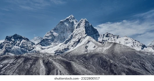
Ama Dablam Peak ("Mother's Necklace", आमा दब्लम, 6,812 metres (22,349 ft))
as seen from Chola Valley.
Khumbu Everest Zone. Nepal, Himalayas.

ama-dablam-bridge

Ama Dablam Expedition

Ama Dablam is a mountain in the eastern Himalayan range of Koshi Province, Nepal. The main peak is 6,812 metres (22,349 ft), the lower western peak is 6,170 metres (20,243 ft). Ama Dablam means "mother's necklace"; the long ridges on each side like the arms of a mother (ama) protecting her child, and the hanging glacier thought of as the dablam, the traditional double-pendant containing pictures of the gods, worn by Sherpa women. For several days, Ama Dablam dominates the eastern sky for anyone trekking to Mount Everest Base Camp. For its soaring ridges and steep faces Ama Dablam is sometimes referred as the "Matterhorn of the Himalayas." The mountain is featured on the one rupee Nepalese banknote.
.

Although Alfred Gregory led the first attempt on Ama Dablam in 1958 it was on 13 March 1961 that the first successful ascent was made, when Mike Gill (NZ), Barry Bishop (US), Mike Ward (UK) and Wally Romanes (NZ) ascended the Southwest Ridge. They were well-acclimatised to altitude, having wintered over at 5,800 metres (19,029 ft) near the base of the peak as part of the 1960–61 Silver Hut expedition, led by Sir Edmund Hillary.

Situated at a distance of 162 km (101 mi) north of the provincial capital of Biratnagar and 152 km (94 mi) northeast to Kathmandu, Ama Dablam is the third most popular Himalayan peak for permitted expeditions. The most popular route by far is the Southwest Ridge (right skyline in the photo). Prior to a 2006 avalanche, climbers typically set up three camps along the ridge with Camp III just below and to the right of the hanging glacier, the Dablam. Any ice that calves off the glacier typically goes left, away from the camp. However, after the avalanche, climbers now prefer to set just two camps to minimize risk. Camp I is at an altitude of over 5,800 metres (19,029 ft), and Camp II is at an altitude of over 6,000 metres (19,685 ft). A climbing permit and a liaison officer are required when attempting Ama Dablam. As with Mount Everest, the best climbing months are April and May (before the monsoon) and September and October.


Ama Dablam peak, Nepal

Ama Dablam peak, Nepal
With its steep, sharp summit, Ama Dablam has been called the 'Matterhorn of the Himalayas.' But in terms of height, the Alpine icon hardly rivals it: Ama Dablam is more than 7,000 feet higher. Here in the world's tallest mountain range, though, it's barely a contender at 22,349 feet—more than 100 of its neighbors rise well past the 23,000 mark. And they're not even fully grown yet: Due to gradual activity in the faults that formed them, the Himalayas rise in elevation almost an inch a year.


Ama Dablam, also known as Amai Dablang, popularly known as “Matterhorn of the Himalay”, is one of the well-known peaks in the Himalaya range. It is the third most popular Himalayan peak permitted for expedition. It belongs to the Mahalangur sub range of the Nepalese Himalayas. The name Ama Dablam mean “Mother’s necklace”. The long ridges on its either side are considered the arms of mother (ama) wich are protecting her child and the hanging glaciers are considered the dablam, which mean a traditional double pendant with the god’s picture imprinted on it, much worn by the Sherpa women in Nepal.


buddhist-stupa-kyanjuma


Ascension de L'amadablam 6814 m


Matterhorn of the HimalayaEverest Region, Nepal
Last light on Ama Dablam (6,812m / 22,349 ft), as shot from up high at 18,500 ft.
*
(I spent three hours above 18k taking in the beautiful transition of light shooting sunset, dusk and astro. It wasn't easy doing so with temps in the single digits but thankfully I was prepared with heavy layers. Following the shoot, I headed down in the dark for a few hours to arrive back at Gorakshep.}

mount-ama-dablam-nepal-mountain-range-glacier-mountains


pngtree-view-from-kumbu-pass-into-the-manaslu-mountains-in-nepal


ama-dablam-mountain-seen-from-the-summit-of-kala-pathar -in-the-everest-region-of-nepal
'Wonderful World' 카테고리의 다른 글
| What Happened To Olympic Gymnast Nadia Comăneci? (2) | 2024.12.20 |
|---|---|
| 중앙선 개통 82년만에 전 구간 복선 전철화 완료…KTX-이음 투입 (0) | 2024.12.20 |
| Monte Vettore, Italy (0) | 2024.12.18 |
| Long-tailed macaque in Ubud Monkey Forest, Bali (1) | 2024.12.16 |
| Vorderer Gosausee, Austria (1) | 2024.12.16 |